An urban design project in the heart of Gloucester. The projects
aim was to come up with a scheme to transform a part of
Gloucester while connecting many of the city centres main
features and buildings.
This first page presents some of the surveying and developing
ideas for the planning proposal. Through examining the way
Gloucester was currently being used, its links, materiality and
architecture, its history, its positives and negatives. This built up
a collection of ideas of the city. How it was a diverse youthful
place with a rich history, particularly that of the Roman era
as well as a real intertwining materiality of brick and stone.
However two key negatives being a lack of greenery and nature
as well as some poorly planned architecture of the 60s and 70s
of large concrete buildings.
Design proposal focused on maintaining this rich materiality
and history to restore an identity back to Gloucester’s, and
to connect the Cathedral and the docks successfully while
creating an exciting new place which can become a focus for
performance, creativity and community within the very core of
the city.
Survey and analysis
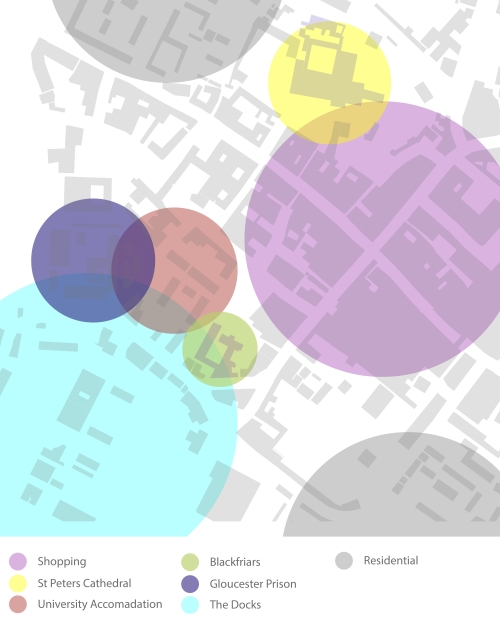
Site Use
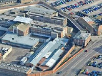
Gloucester Prison
University accommodation
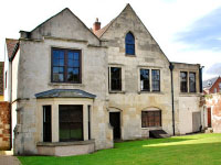
Blackfriars: A medieval Dominican Priory
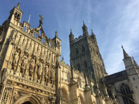
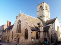
St Peter's Cathedral
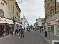
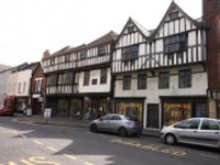
Shops along Southgate street
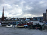
The Docks
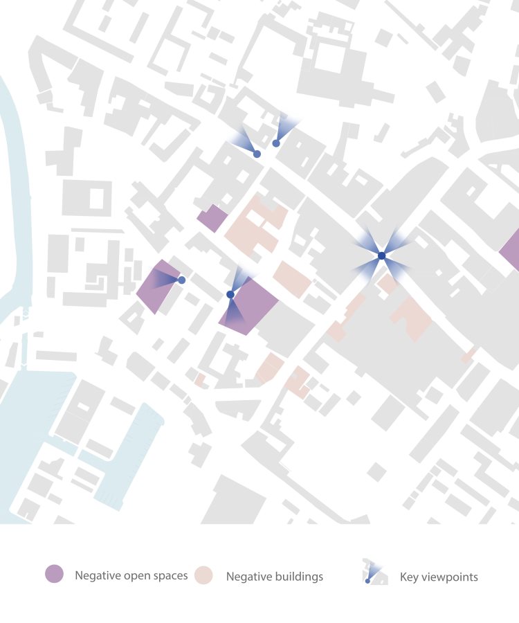
Site analysis
The site analysis map presents some of the negative buildings and open spaces of the site that present possible opportunities and also possible constraints when designing. It also shows key view points within the site which are important to the site.
Materiality
Gloucester’s rich history means that there is a variety of materials used throughout the city centre. The survival of several medieval stone undercrofts, associated with wealthy merchants’ houses and several outstanding timber-framed houses of the 15th-17th centuries stand within mostly bricked buildings and a brick and stone paved centre, also with early medieval churches made of stone, most notably St Peters Cathedral and surround. This brick and stone use should be enhanced and celebrated within the design, creating special areas that connect Gloucester, especially in areas that have become rundown or lost their identity to the more 1930s and postWWII developments that have ruined the historic streets, with large concrete block buildings.

Site Users
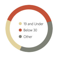
- Population: 128,500
- High population density
- Diverse city with black and minority ethnic population at 13.4%
- Approximately 100 languages and dialects spoken
- Relatively young city with 25% of the population aged 19 and under and 39% under 30
- Eating/Drinking
- Meeting
- Work/Business
- Shopping
- University/Schools
- Residential
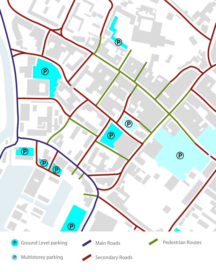
Site Links
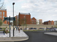
Mapped out routeways showing the small amount of pedestrian roads, located mainly along westgate street around the shopping areas, with small paths south and north branching off. Possibility to remove some vehicular roads to make the site more pedestrian friendly. High level of car parking gives flexibility to remove some if needed.
Architectural Context
The centre of the city of Gloucester is located between
The Docks and the Cathedral and has a vast example
of architecture within it with commercial, local
government, cultural and residential uses. There are
many different eras of architecture throughout history
on display in Gloucester from Roman walls and street
layout to the Victorian Gloucester Docks.
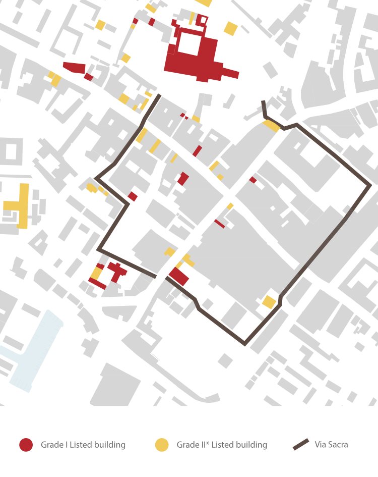
Gloucester has many Grade I and Grade II* listed
buildings (shown in Historic and spatial Context Map)
such as buildings on Brunswick Road, used as the
library and museum, as well as two outstanding 12th
century friaries – Blackfriars and Greyfriars, which are
key historic architectural buildings that are important
to Gloucester’s history. Many buildings with religious
or secular uses, date back to between the 11th and the
19th centuries
such as several very early medieval churches like
St Mary de Crypt on Southgate Street, St Nicholas’
Church on Westgate Street, St John the Baptist
along Northgate Street and St Michael’s Church
where only the tower remains on Eastgate Street.
There is a survival of several medieval stone
undercrofts, associated with wealthy merchants’
houses and several outstanding timber-framed
houses of the 15th-17th centuries.
All these buildings build up a historic character of
the whole centre of Gloucester and collection of
materials that are used to make them. Brick with
stone becomes a prominent material throughout
Gloucester and creates an sense of identity and
place as a city.
St Mary de crypt Church
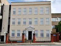
Ladybellegate House
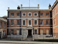
Bearland House
The Folk museum
History and spatial Context
Gloucester was a Roman City formed around AD 81 after the Roman fortress that was established at Kingsholm around AD 48, that acted as the frontier between Roman Britain and unconquered Wales, was dismantled and a Colonia, a city where soldiers retiring from the army were given land as a form of pension was created to the South, this was called ‘Glevum’, what we now know as Gloucester.
This period saw the establishment of a
rectilinear street pattern that still underlies
the historic centre of Gloucester today. The
Cross, marking the centre of today’s city, also
stands on top of the focal point of the Roman
city. Northgate Street and Southgate Streets
lie directly on top of the main Roman road
through the city. London Road also follows a
Roman alignment, turning north easterly to
join Roman Ermin Way (today’s A38 Barnwood
/ Hucclecote Road). Ermin Way itself is aligned
on the original fort at Kingsholm.
This Roman history and street layout is
something I think is very prominent in its
identity and feel of the place, as well as its
materiality with heavy use of brick and stone.
Design could enhance this character, placing
emphasis on specific types of Roman spaces.
The Via Sacra is a pedestrian route that roughly
follows the line of the Roman walls enclosing
the old town. Beyond Westgate Street, it
follows Berkeley Street, then skirts the remains
of the Blackfriars Dominican priory, St Mary
De Crypt Church, and the ruins of Greyfriars,
before continuing to the cathedral via College
Court. It was a concept which celebrates
Gloucester’s Roman History. However in many
areas, the paving or the surrounding landscape
are in need of enhancement.
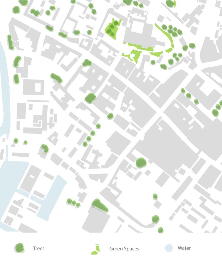
Ecology
Very low amounts of planting or green space
within gloucester centre and around the site.
Only green space around the Cathedral.
Consideration for new green areas and
more planting key in design. Key trees along
LadyBellegate Street and the south end of
Berkley Street.
Within the City Centre the topography is largely
flat with the high point close to the crossing
point of the four main streets There is a steeper
drop occurring on the west side of Ladybellegate
Street. The change in gradient is also particularly
noticeable along Westgate Street, which drops
gradually towards the river and the historic quay
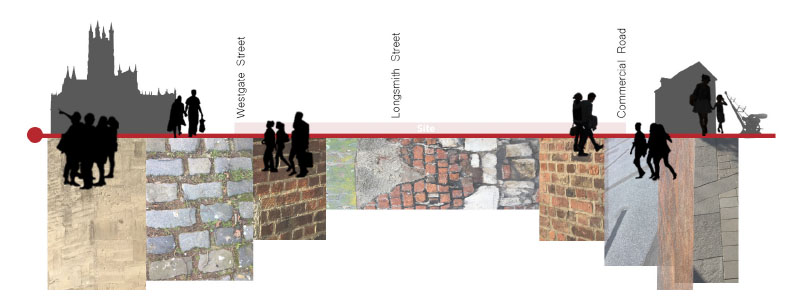
Concept Mapping
The concept map shows a section line starting at the Cathedral to the north of central Gloucester to the docks, at the south. The rich materiality of Gloucester is something that is personally very striking and at the forefront of its identity, which I’ve presented below the section line, blending the different materials to show the use of bricks and stone that make up Gloucester. More effective areas like the Cathedral and docks have the more crisp stone finish to them which are presented below these points. The central area between Westgate street and commercial Road is more confused and messy as lots of these areas have become run-down and confused with the addition of newer poor quality buildings like the concrete telephone exchange and run-down derelict brick
buildings around blackfriars. People along the section show areas such as the Cathedral and docks being used by people for sightseeing or shopping as well as westgate being used for shopping. However it presents the lack of activity currently on the site, with people facing outwards of the site as its become undesirable to be within as its become run-down with a heavy lack of activity. The design should address this issue creating spaces and streets that encapsulate the materiality effectively to create continuity throughout Gloucester centre and create spaces for more activity then just walking and shopping, to encourage people to spend time relaxing in.
Concept
Concept
The city of Gloucester owes its name, location and much of its physical layout, to nearly five hundred years of Roman occupation. The city’s Roman name was Glevum, and was a Colonia, a very special high-status city, one of only four to be established in Roman England. Its military origins were reflected in its huge walls, gates and regular grid street layout and was a great cultural city, boasting impressive civic buildings, imposing statues, forum and baths.
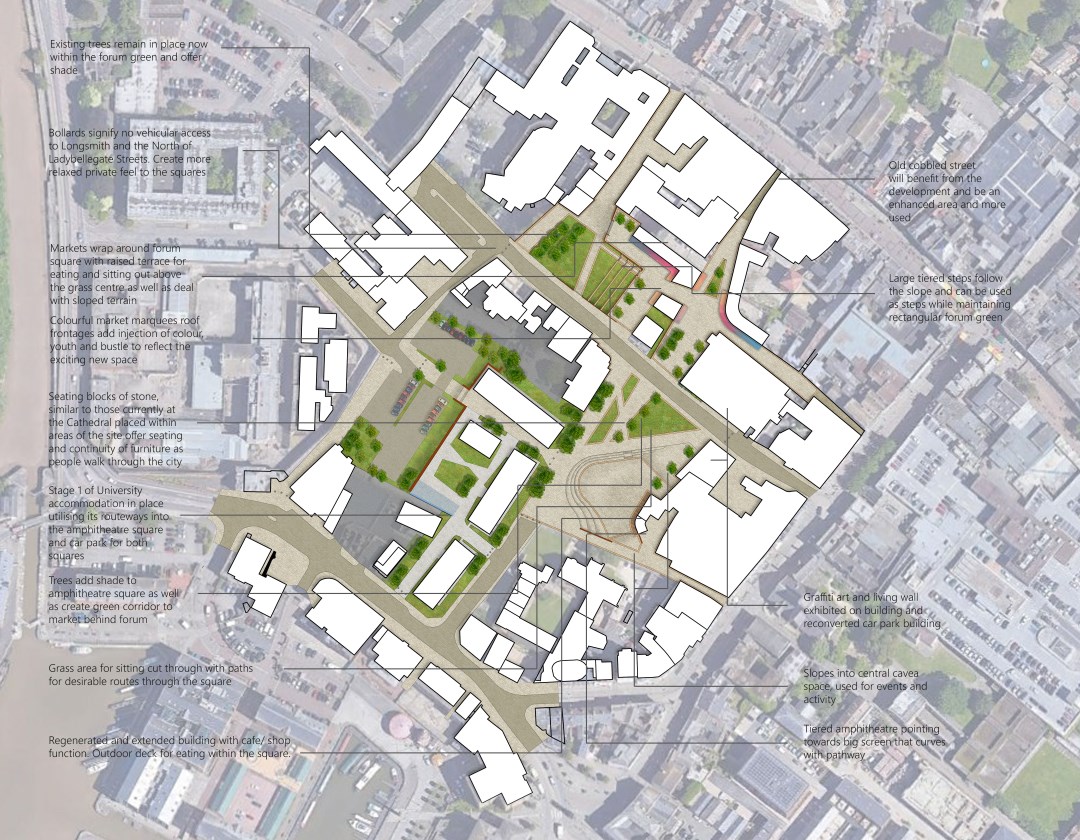
The existing street pattern of today’s city centre often follows that of Roman Glevum which influence the vision of the design that is to enhance Gloucester’s historical identity and create continuity through the city centre, celebrating this Roman history and street layout. The vision is centred around the creation of new squares and streets that are inspired by Roman Glevum (Gloucester) and Roman spaces such as the Cavea and forum. Design will be informed using the main spatial features of these spaces to create successful public squares, becoming the ‘Glevum’s squares’ for the whole of the cities community.
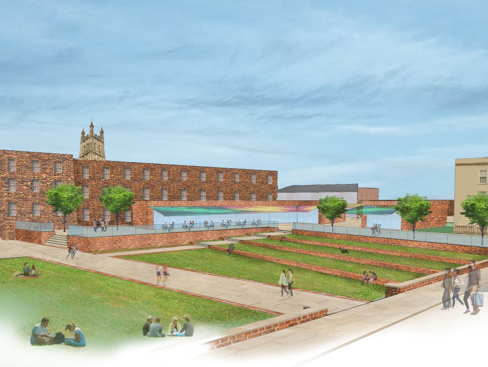
The cavea, which in Roman times referred to the seating sections of Roman theatres and amphitheatres will inspire the inclusion of an amphitheatre within one of the Glevum squares that’s cavea and open space within can become a multifunctional space and hub of activity for the use of performance, a place to watch events, as well as tying together the Docks and Blackfriars, to the High street and Cathedral as a central focal space.
As well as this Roman space, the Forum, an open area space that was historically surrounded by several important government buildings at the centre of a city serving as a public marketplace, in which commercial, religious, economic, political, legal, and social activities occurred, will Inspire the idea of a public marketplace and open area incorporated within the ‘Glevum squares’. A square will be inspired by the layout of the Roman forums and sit within the space of the proposed demolition of the telephone exchange building on the corner of Berkley and Bearland Street, a large concrete post WWII building that currently overbears the surrounding historical buildings like Bearland House, Ladybellegate House
and the courthouse. This will open up space for an open area just off Gloucester’s Westgate high street to become a market area for shopping and eating, while maintaining a Roman forum style open layout used for leisure and relaxing within, surrounded by some of Gloucester’s historical and important buildings.
The design should consider the rich current palette of materials within Gloucester, such as stone and ceramic building materials, but also have a contemporary edge that updates and refreshes Gloucester centre, as well as the inclusion of more much needed green space and planting.
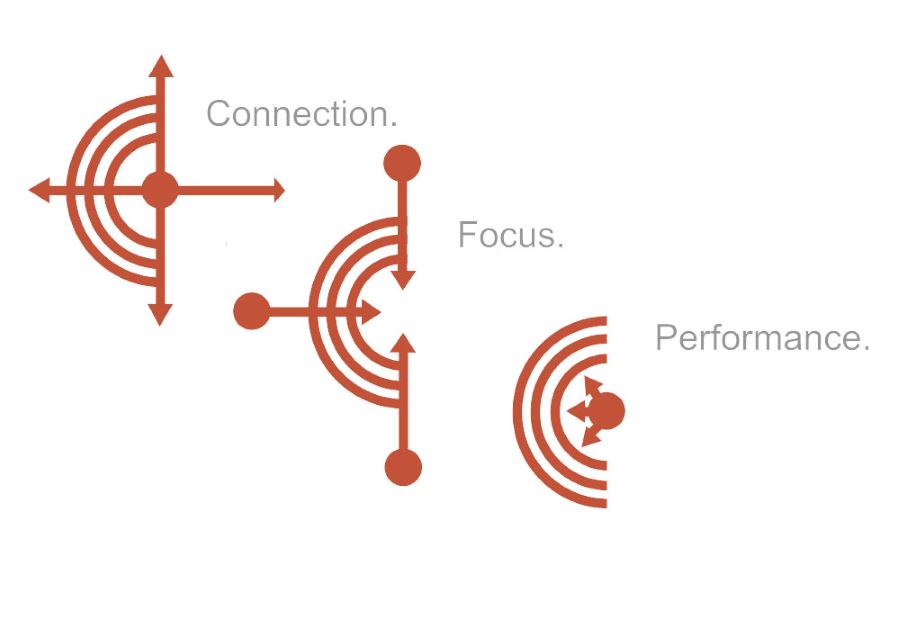
The concept images below shows a conceptual visual of how the amphitheatre and forum squares will improve as well as function as public squares and spaces within Gloucester. The three graphics all contain a tiered semi circular shape that represents the amphitheatre with the central point representing the cavea and open space used for activity and events. Each graphic differs slightly representing a different contribution the space will offer to Gloucester, each annotated with one summarising word, ‘Connection’, ‘Focus’ and ‘Performance’.
‘Connection’- Represents how the amphitheatre aims to connect all the sites of Gloucester such as The Docks and Blackfriars to the High street and Cathedral. The circle within the centre branches out like the The Cross within Gloucester and arrows point out to the rest of Gloucester.
‘Focus’- Represents how the amphitheatre aims to become a focal point and focus within Gloucester. The arrows point inwards to the cavea signifying how people from within the city will come into the site to use the space.
‘Performance’- Represents the amphitheatre use. The amphitheatre square will be a multifunctional space for community events and activities as well as use for performance of live music, theatre or the display of sporting events. This is presented by small arrows from the centre of the amphitheatre that evoke the idea of the performances and activity that will bring the space, and Gloucester to life.
Design